PHASE 1 · AI SKY TRACKER
A low-cost visual sensing platform, starting with one passive sky-tracking node.
A camera, a model and a pan-tilt mount that watch the sky, follow what they see and log every sighting.
About $113 in new parts for the sensing hardware (camera, servos, mount, power), before the computer that runs the model.
- Passive sensing only
- Solar power planned
- MIT licensed
01The math is backwards
A small drone costs a few hundred dollars. Systems built to detect one cost tens of thousands.
- A small drone
- $100s
- Typical detection system
- $10,000s
- Skynode sensing parts, before the computer
- ~$113
Price comparison only, not a capability comparison. Skynode is one passive camera node and has not run on real hardware yet.
Skynode is a first step toward making that sensing layer cheap enough to put anywhere.
Early use cases I'm exploring: farms, small airports, stadiums, and power substations. First hypothesis to test: small general-aviation airfields.
02System
How it works
-
01 28,526 IMAGES
SENSE
A YOLO object-detection model looks at the camera feed and picks out aircraft and drones. It is training now on a dataset of 28,526 labeled images.
-
02 P92.5 T47.0
TRACK
A Raspberry Pi Pico drives two small servos on a pan-tilt mount, turning the camera to keep the target centered.
-
03 TIME · CLASS · CONF
LOG
Every sighting will be saved with the time, what it was, how confident the model was, and which way the camera was pointing.
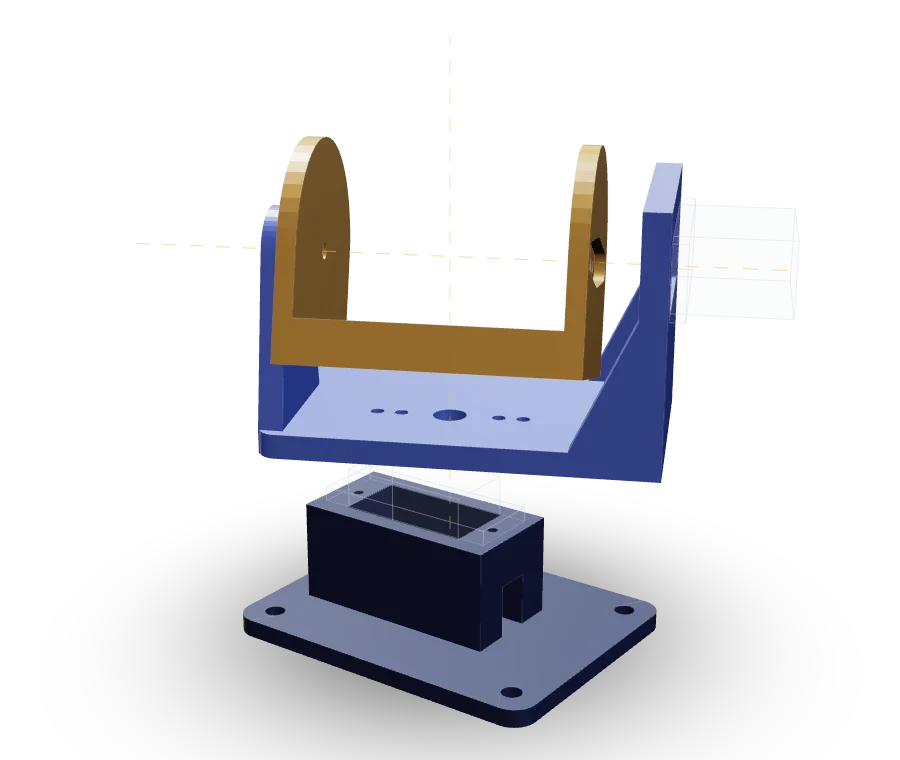
PAN-TILT MOUNT
- BASE
Holds the pan servo, shaft up, and screws down with four M3 screws.
- YOKE
Sits on the pan horn, holds the tilt servo, and carries the M3 pivot.
- CAMERA ARM
Webcam cradle on the tilt horn and pivot.
Rendered live from the CAD files in this repo, with the two servos drawn as outlines, and moved through its pan and tilt axes. The physical build is next.
The test range is free: real air traffic passes overhead all day. Planes publicly broadcast their positions (ADS-B), so I can compare what the camera saw with what actually flew over and report real accuracy numbers.
03Where it stands
Status
-
Pico servo firmware: smooth motion, calibration, command protocol
DONE -
Detection and tracking loop, working in simulation, 226 automated tests
DONE -
Pan-tilt mount designed in CAD, with STEP and STL files
DONE -
Wiring diagram and bill of materials
DONE -
Sighting logger (built and tested in simulation)
DONE -
Live dashboard (built and tested in simulation)
DONE -
Detection model v3 with drone and aircraft classes (in training)
IN PROGRESS -
Run the logger and dashboard on real hardware
NEXT -
Build the physical hardware
NEXT -
Outdoor test
NEXT -
Test against real flight data (ADS-B) and publish accuracy results
NEXT -
Pi 4 + solar deployment
NEXT
Results so far
The v2 model, run on 43 real-world videos of planes, military jets and drones. This tests the model on recorded video. It is not a hardware test.
- False-drone rate on real aircraft
- 7.5%
- 798 of 10,657 frames were called a drone
- Civilian planes called drones
- 0.8%
- Military jets called drones
- 10.8%
- Mostly distant F-35s
Model v2, 43 real-world videos. v3 (drone and aircraft classes, 960 px input) is in training. There are no v3 results yet.
04Honest limits
Known limits
-
RANGE · ESTIMATE
A wide-lens webcam detects small drones only at short range, likely tens of meters (an estimate, still to be measured). Aircraft are detectable much farther.
-
CONDITIONS
Visual sensing is weaker in darkness, fog and rain.
-
NOT REMOTE ID
It can see drones that broadcast nothing, unlike Remote ID, but it does not replace Remote ID or RF sensors.
-
NOT BUILT YET
Nothing has run on real hardware yet.
05About me
I'm Braden, I'm 14, and I like building things that work in the real world. I started with Sunnode, a small server that runs entirely on solar power from a panel on my fence. Then I got curious about drones, trained my first detection model, and Skynode was the next step. I've run a backyard gardening business, and I shelved a software startup after learning how hard it is to sell to companies when you're 13. I'm fascinated by geopolitics and technology, and I want to build an aerospace and defense company someday. Skynode is where I'm starting.
“You only live once so go out there and make the most of every moment by chasing your dreams and living without regret”
— Braden06Roadmap
From one node to a company
This is Phase 1. The long-term goal is autonomy for missile and drone detection and defense systems.
-
PHASE 1 · NOW
One working node
A camera that detects, tracks, and logs aircraft and drones, with real accuracy numbers.
-
PHASE 2
A network of nodes
Several nodes working together can work out where a drone is and where it is heading.
-
PHASE 3
Autonomous drones
For inspection, search and rescue, and drone detection and defense systems, built on the same sensing and tracking brain.
-
PHASE 4
A company
An aerospace and defense company building autonomy for missile and drone detection and defense systems, once I'm old enough to start one.
Phase 1 is passive by design. It carries no payloads, never jams, and never transmits on aircraft or drone frequencies. It only watches.